

THE DEVELOPMENT OF THE TOWN OF JURBARKAS IN THE 15TH–17TH CENTURIES
Relatively little is known about the development of the town of Jurbarkas in the 15th–16th centuries. So far, virtually the only evidence of a settlement in the area during the early Middle Ages is the ancient settlement located near the Jurbarkas hillfort. Sooner or later, it was moved even closer to the Nemunas River, although it is likely that a settlement near the Nemunas already existed in the 15th century. The road running along the Nemunas from Kaunas to Prussia (and vice versa) was of great importance, and it was precisely this trade route that improved the conditions for the town’s development. The strategic importance of the location was further enhanced by the 1422 Treaty of Melno, which established the state border between the Grand Duchy of Lithuania and the Teutonic Order, as the road connecting the two states ran precisely through this area.
The only reliable data on the settlement of the area dating back to the early period of the town’s development are the plots of land granted by Vytautas in 1421 to the Veliuona Church, located on the eastern bank of the Imsrė river. There were taverns and shops there, a market likely took place, and there were probably several residential buildings as well. The Grand Duke’s manor estate is believed to have been situated between the Imsrė and Mituva rivers, slightly north of their confluence (from today’s perspective, this would likely be the area around Tilžės Street and the bus station). In summary, it is most likely that in the 15th century, Jurbarkas was a linear settlement with the ruler’s manor located to the west of the settlement itself. By the early 16th century, Jurbarkas was already referred to as a parish.
Around 1530, the then-ruler Sigismund I the Old transferred the administration of the Jurbarkas and Virbalis (then called Nova Volia) parishes to his wife Bona Sforza, whose initiative in managing the estates served as a stimulus for Jurbarkas to expand and grow. In the summer of 1540, by order of the ruler, Bona Sforza’s deputy Jonas Kuncevičius (who was also the customs officer of Kaunas) established a customs post; in addition to the authorized market, merchants set up salt warehouses. In addition to the customs office itself, efforts to “develop the town” began immediately: a marketplace was established, and the settlement itself was expanded, with the expansion adhering to the requirements introduced following the general land reform. There is no data on exactly when this was done, but it is likely that the center of the settlement was moved closer to the manor estate, i.e., between the Imsrė and Mituva rivers. A square shaped or rectangular shaped market square was established, with streets running perpendicular from its corners. Perhaps when designing the layout of the future town, the established standards and norms of the time were used to measure the central squares of settlements, or at least the configuration of the central square was planned using a similar model. The current Old Town of Kaunas was developed in a similar manner.
Until then, Jurbarkas had been merely a plot of land belonging to the church (the parish of Veliuona), but now a church was being established and built in Jurbarkas itself. It is mentioned that by 1545, a church already stood at the site chosen by Jonas Kuncevičius himself, along with a building for the clergy to live in. It is most likely that the church was built roughly where the Church of the Holy Trinity in Jurbarkas stands today, i.e., approximately between the old former settlement and the new one.
In 1561, when Sigismund Augustus pledged the territory of Jurbarkas to the Duke of Prussia, Albrecht, a fairly detailed inventory of the new settlement (between the Mituva and Imsrė rivers) was drawn up, which confirms the assumptions regarding the layout of the settlement. Architect and historian A. Miškinis has published reconstructions of the settlement on multiple occasions. In 1567, Kristupas Konarskis purchased the Jurbarkas district from Albrecht; residents soon began to complain about his actions, leading to investigations even by commissioners appointed by the ruler.
An important date in the town’s history: in 1611, at the request of its residents, Jurbarkas was granted Magdeburg rights, which allowed the town to operate more independently. Throughout the first half of the 17th century, the town expanded and grew; as space became scarce in the central part, the town began to expand eastward once again.
A turning point in the town’s (and the entire country’s) history was the wars with Moscow and the Swedes that broke out in the mid-17th century. A Swedish garrison had settled in Jurbarkas, and after their “visit,” only eight farmsteads and an inn remained in the city: practically everything had been burned down, and virtually all of the heritage significant to the city’s history and legacy was lost. Gradually, the most important buildings in the town were rebuilt, but due to the wars of the mid-17th century and the frequent fires that followed, Jurbarkas grew and expanded with great difficulty.
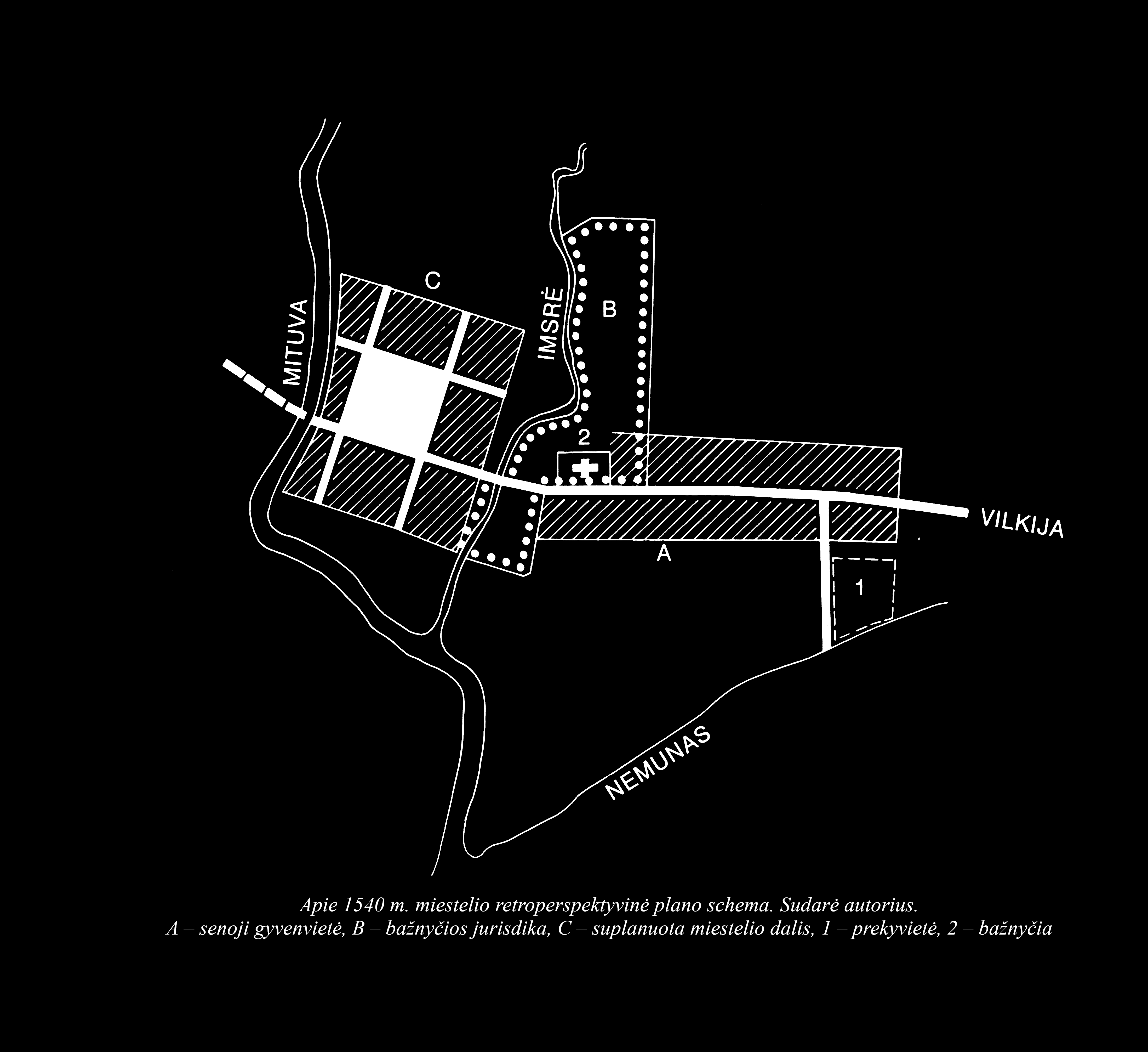
The town of Jurbarkas in the mid-16th century. Based on historical data. Reconstructed and map created by A. Miškinis


